גארמין GPSMAP H1 Plus
ה‑GPS החזק ביותר של גארמין – ניווט, תקשורת ותמונות, בכל מקום בעולם
1300
1250
$
לפני מעמ
The H1i Plus delivers precise navigation, SOS emergency communications, and advanced documentation capabilities. It’s ideal for hikers, explorers, outdoor enthusiasts, and sailors. It redefines what you can do outside of a network.
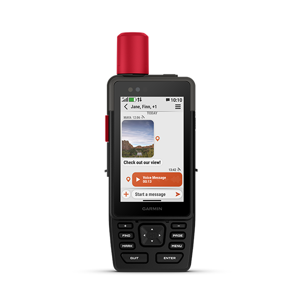
The device combines a large color touchscreen with physical buttons for easy use in all terrain conditions.
Includes inReach Plus technology that allows you to send messages, photos, and voice messages even without cellular reception.
A built-in camera and microphone allow for direct satellite recording and sending.
The device is equipped with built-in TopoActive maps and the ability to download satellite photos.
The long battery life allows for days of travel without recharging.
אודות
Garmin GPSMAP H1iPlus is one of the most advanced and powerful satellite navigation and communication devices that Garmin has ever produced, and is designed for travelers, explorers and field workers who need a complete combination of navigation, safety and communication in all conditions.
The device is equipped with a 3.5-inch color touchscreen along with physical buttons, which allows precise operation even with gloves, in rain or extreme cold.
The new inReach Plus technology allows sending text messages, photos and voice messages via the global Iridium network, so you can stay in touch even in areas without cellular reception. In addition, the device includes a built-in camera and microphone that allow for direct documentation and sending from the field without the need for a phone.
The H1i Plus comes with detailed TopoActive maps, support for downloading satellite images and advanced navigation capabilities that include routes, points of interest and extremely high accuracy.
The rugged IP67-rated structure ensures complete resistance to dust, drops and water, and the powerful internal battery allows for extended use on long journeys.
This is a device that combines professional navigation, emergency communication, documentation and intuitive operation – a complete solution for anyone who spends a lot of time in the field and needs security, reliability and communication capabilities in any situation.
מפרט טכני
Structure and durability
- Resistance standard: IP67 – Dust and submersible up to 1 meter for 30 minutes
- Operating temperature: -20°C to 60°C
- Charging temperature: -15°C to 60°C
Screen and operation:
- 3.5-inch color touchscreen with hybrid physical buttons
Communication and satellites
- inReach Plus technology – Send texts, photos and voice messages via the Iridium network
- SOS to the Garmin Response Center (requires subscription)
Maps and navigation
- Built-in TopoActive maps
- Support for downloading satellite photos
- Full terrain navigation, routes, points of interest and more
Camera and microphone:
- Built-in camera for taking pictures and sending via satellite
- Microphone for voice messages (Voice Notes)
Battery:
- Internal rechargeable battery (according to official specifications on the Garmin website)
- Battery life varies depending on usage mode (GPS, inReach, Satellite imagery)
Connectivity:
- Bluetooth
- Wi-Fi
- USB-C
Dimensions and weight:
Device dimensions: 17.9 × 6.7 × 3.3 cm (height × width × thickness).
Weight: 290 g.
Screen size: 3.5 inches diagonally (physical display dimensions: 7.7 × 4.7 cm).
קבוצת תמיכה בווטסאפ
Do you have any more questions?
Leave your details and we will get back to you as soon as possible.